

Tornado watch in Twin Cities, hail hammers Minnesota
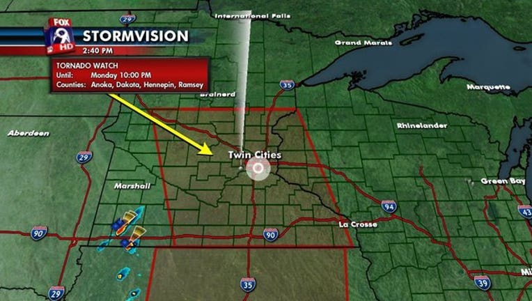
MINNEAPOLIS (KMSP) - A tornado watch has been issued until 10 p.m. Monday, March 6 for areas of central and southern Minnesota and western Wisconsin. The watch area includes the Twin Cities metro. Get the Fox 9 Weather App to track the storm timing and impact, specific to your location.
Threats include damaging winds up to 65 mph, large hail and isolated tornadoes
5:56 PM - Confirmed tornado located over the south side of Princeton, Minnesota, moving northeast at 40 mph.
5:49 PM - Confirmed tornado located near Zimmerman, Minnesota. PHOTOS
5:40 PM - Report of grapefruit sized hail in Cokato, Minnesota.
5:36 PM - Tornado warning radar indicated Sherburne County until 6 p.m.
5:05 PM - Public reports of ping pong ball sized hail near Bricelyn, Minnesota (Faribault County).
5 PM - Public reports of golf ball sized hail in Cokato, Minnesota (Wright County).
4:50 PM - Tornado warning issued for Wright County, with 1.25 in. hail reported. Expired at 5:15 p.m.
Seattle out-snows Minneapolis
Thanks to our warm winter, and over half of our winter precipitation falling as rain, the Twin Cities actually experienced fewer flakes in January & February combined than Seattle did. This is the first time this has happened since 1969, nearly 50 years ago. READ MORE - For the first time in decades, Seattle out-snows Minneapolis
Better forecasts are wanted, but nobody wants to pay for it
Weather forecasting has advanced leaps and bounds over what it was 20, 30, or 40 years ago. Our forecast 4 days away in 2017, are as good as what a 12 hour forecast was in 1990. But let’s face it, advances in meteorology don’t just come out of thin air. Science and technology costs money for sustained research and development. KEEP READING