MN weather: Storms north of Twin Cities developing late Friday

MN weather: Steamy weekend forecast update
FOX 9's Keith Marler shares an update to the forecast, which includes possible storms on Friday night and a hot weekend.
DULUTH, Minn. (FOX 9) - Several clusters or a line of storms are expected to develop late Friday, mainly across northern Minnesota.
What to expect with Friday's possible storms
Local perspective:
A warm front stretching through southern Minnesota will slowly edge northward on Friday night around midnight to 1 a.m.. Ahead of that front, storms will likely fire up around or not long after sunset.
If the front is slow, there is the potential for initial storms along the Interstate 94 corridor, which could include parts of the northern Twin Cities metro. That area is under a Level 1 risk for severe weather.
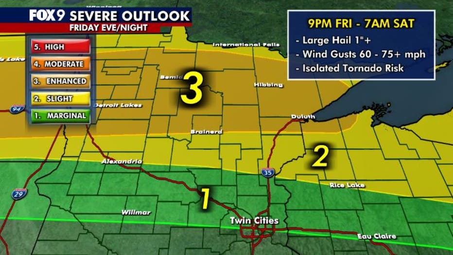
However, it's more likely that storms will fire up farther north, toward Mille Lacs or Brainerd, and quickly expand into clusters or a line of storms that stretch across much of northern Minnesota and northwestern Wisconsin overnight.
Gusty winds, large hail and isolated tornadoes are possible with storms across the northern third of the state into early Saturday. If storms congeal into a line, widespread wind damage is possible with gusts of up to 80 mph.
Timing of the storms
Timeline:
The timing of the storms in northern Minnesota on Friday is looking like 12 a.m. to 2 a.m. on Saturday.
For the Twin Cities metro, if storms develop in the area, they'll likely develop around sunset.
Hot weekend ahead

Preparing for extreme heat in Minnesota
Minnesota is bracing for extreme heat just as summer begins, with temperatures pushing into the mid-90s and heat indices exceeding 100 degrees. FOX 9 meteorologist Cody Matz has more on what to expect and how you can prepare.
What's next:
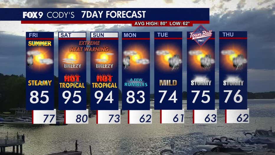
This weekend will be hot, steamy and breezy with temperatures in the 90s and heat index values into the tipple digits.
An extreme heat warning is in effect from noon on Saturday to 9 p.m. on Sunday for much of central and southern Minnesota, along with a heat advisory for northern regions. Due to the extreme heat, we could see record overnight lows.
Storm chances return early next week, along with more comfortable temperatures in the 70s.
Here’s a look at your seven-day forecast: