

Minnesota weather: Tornado warnings, flash floods in southern counties Wednesday
MINNEAPOLIS (FOX 9) - Widespread storms led to heavy rain and flash floods across Minnesota, and the National Weather Service issued a tornado warning in the southern part of the state.
You can find live updates below.
7:30 p.m. - Tornado, flash flood warnings in southern Minnesota
The National Weather Service issued a tornado warning for Waseca County and Blue Earth County, saying there was an "extraordinary threat to life or property" in the area. The warning expired at 8 p.m.
A flash flood warning was also issued for Rock County, with the National Weather Service saying there was a "significant threat to life or property" in the county. That warning is set to expire at 7 p.m. on July 27.
3:30 p.m. - Reports of flooding following heavy rain
A viewer shared photos showing some localized flooding in Avon, Minn. There were separate reports of flooding in Elko, Minn. following rain.
Noon and 1:30 p.m.- Flash flood warnings
The National Weather Service issued a flash flood warning for Ely until 1:45 p.m. in addition to Sartell, Albany and Avon until 1:15 p.m.
A flash flood warning has been issued for the northwest metro until 2:15 p.m. This warning is for parts of Anoka and Hennepin counties, including Maple Grove, Coon Rapids and Blaine. There are reports of 1.5+ inches of rain falling in the last hour, with a rainfall rate of 2+ inches an hour.
10 a.m. - Rain moves in

MN weather: Heavy downpours in metro
FOX 9 meteorologist Jared Piepenburg has the latest development in Wednesday’s showers and storms.
Some rain began falling in Eden Prairie on Wednesday morning.
Meanwhile, special weather statements have been issued for areas around St. Cloud and Sartell until 10 a.m., with the National Weather Service saying hail and wind are possible.
Get location-based weather alerts on your mobile device by downloading the FOX 9 weather app and allowing notifications.
A severe thunderstorm watch is in effect for Big Stone County and Traverse County until 1 p.m. You can find the latest weather alerts here.
Additionally, flooding has been reported in the Leech Lake to Iron Range region of northern Minnesota due to multiple rounds of heavy rain, according to a post by the Duluth National Weather Service.
Wednesday’s forecast in Minnesota

MN weather: Late day storms on Wednesday
It's hot and steamy ahead of late day storms on Wednesday. A heat advisory is in effect from noon until 8 p.m. for the Twin Cities and southern Minnesota, as the heat index is expected to reach near 100 degrees.
Heat advisory:
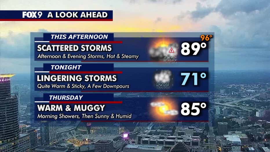
Temperatures warm into the mid and upper 80s across central and southern Minnesota, with cooler 70s up north. The Twin Cities metro daytime high is around 89 degrees.
A heat advisory has been issued from noon to 8 p.m. for the metro and areas south as heat index values approach the triple digits.
(FOX 9)
Storm chances:
Scattered showers and storms are possible in the metro this afternoon and evening, though a stray midday shower or rumble can’t be ruled out. There is a level 1 risk of severe weather in north central Minnesota and a level 2 risk for the Twin Cities and southern Minnesota on Wednesday.
High dew points will help fuel local downpours as storms move in on Wednesday. A few storms may produce gusty winds of 60 to 70 mph. Downpours may also lead to flooding concerns as some drainage may not be able to keep up. There is also a low risk of isolated tornadoes and hail.
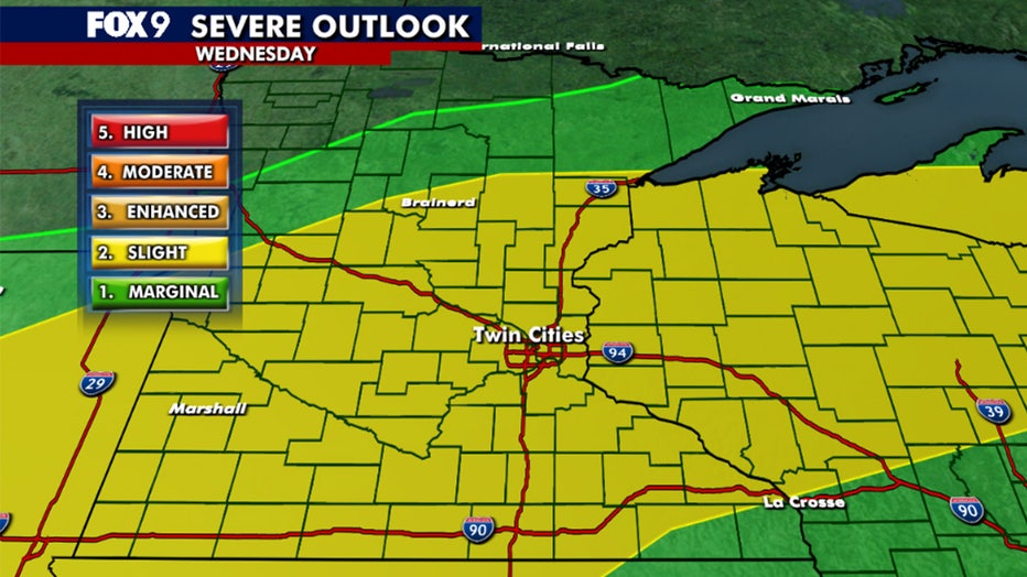
Severe weather outlook map for July 23, 2025. (FOX 9)
Extended forecast
What's next:
Showers and rumbles may linger through Thursday morning but clear for a mostly dry day with highs in the 80s. Friday brings a temporary drop in humidity, with dew points in the 60s.
The weekend will be muggy with rising dew points and temperatures back in the upper 80s. A spotty shower or thunderstorm is possible late Sunday and Monday night.
Here's a look at the seven-day forecast:

(FOX 9)
The Source: Information for this story was provided by FOX 9 meteorologists.